⊗
The purpose of this glossary is to assist in the understanding of common terms related to the Timor Sea, maritime boundaries and the United Nations Convention on the Law of the Sea. The glossary is not intended to be a comprehensive list of all relevant terms and the explanations provided are not technical or legal in nature.
| Term | Explanation |
| Adjacent coasts | Coasts which are next to each other, such as the coasts of West Timor (Indonesia) and the mainland of Timor-Leste. |
| Archipelagic baselines | If a country is considered an Archipelagic State under the United Nations Convention on the Law of the Sea, it may use straight archipelagic baselines on the outer limit of its main islands, to measure the breadth of its territorial sea. Generally, archipelagic baselines are not used in maritime boundary delimitation between States. Indonesia is an example of an Archipelagic State – waters between the main islands in Indonesia are treated as internal waters under the United Nations Convention on the Law of the Sea. |
| Archipelago | A group of islands and interconnecting waters which are so close to each other so as to be considered to be a single entity, such as Indonesia. |
| ‘Carve out’ (of maritime boundary jurisdiction) | The term often used to describe when a State withdraws from the compulsory dispute resolution procedures under the United Nations Convention on the Law of the Sea. Australia ‘carved out’ this jurisdiction under the convention two months before Timor-Leste’s restoration of independence day in 2002. This means that Timor-Leste cannot ask the International Court of Justice or International Tribunal for the Law of the Sea to make a binding determination of a maritime boundary between Australia and Timor-Leste. |
| Coastal State | A term used in the United Nations Convention on the Law of the Sea to describe a country which has a coast. |
| Compulsory Conciliation | A procedure under UNCLOS in which a panel of conciliators assists State parties to reach an amicable settlement of their dispute. |
| Concave (coastline) | A coastline that curves inwards. |
| Continental shelf | The continental shelf comprises the seabed and subsoil beneath it. Under UNCLOS, a coastal State is entitled to a continental shelf which extends to at least 200 nautical miles from a State’s baselines. In some cases (for instance where there are no overlapping claims by another State), a State can claim an extended continental shelf beyond 200 nautical miles where there is a ‘natural prolongation’ of the shelf. Australia has recognised continental shelf claims beyond its 200 nautical mile Exclusive Economic Zone in certain parts of its coastline. |
| Convex (coastline) | A coastline that curves outwards. |
| Delimitation | The drawing of a maritime boundary. |
| Document seizure case | This case was between Australia and Timor-Leste and it was heard before the International Court of Justice. In 2013, Australian security agents took a number of documents from one of Timor-Leste’s lawyers in Canberra, Australia. Australia alleged that the material contained classified information. Timor-Leste argued that the documents should not have been seized. In a provisional measures order (which is not a final order), the majority of the International Court of Justice judges said that Australia should seal the documents (and not look at them) and that Australia should not interfere with Timor-Leste’s communications with its lawyers. The case was later discontinued by Timor-Leste after Australia returned the documents. This case is different to the Timor Sea Treaty Arbitration. |
| Equidistance line (of a maritime boundary) | A continuous line which is equidistant (that is, halfway) between two opposite or adjacent coasts. For example, if two countries agree to a maritime boundary which follows an equidistance line, that boundary is exactly in the middle of both countries (note that it might curve or turn sharply to reflect the two countries’ coastlines and so that the line is exactly equidistant from both coasts at all points along the line). An equidistance line has the same meaning as a median line. |
| Exclusive Economic Zone (EEZ) | The Exclusive Economic Zone extends up to 200 nautical miles from a State’s baselines. Within that zone, States have the right to exploit living and non-living resources in the seabed, subsoil and water column, including petroleum resources and fisheries. |
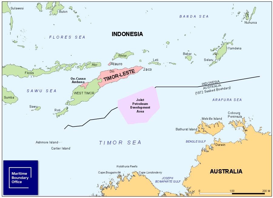
| Greater Sunrise | The largest known oil and gas reserve in the Timor Sea. The Greater Sunrise field is comprised of the Sunrise field and Troubadour field. Other notable fields in the Timor Sea include Bayu-Undan, Laminaria, Corallina, Buffalo, Kitan, Elang and Kakatua. |
| High seas | The area of the ocean where no country may claim maritime rights. The high seas are common to all humankind. |
| Internal waters | Waters which are located on the landward side of a country’s baselines. For instance, a river or a lake. A State has similar rights to its internal waters as it does to its land. There is a special rule for Archipelagic States, which says that all waters within the archipelago are considered to be internal waters. |
| International Court of Justice (ICJ) | The main court of the United Nations, also popularly known as the ‘World Court’. Only States (i.e. countries) can be a party to proceedings before this court. The United Nations Convention on the Law of the Sea gives the International Court of Justice jurisdiction to hear maritime boundary disputes between countries. The International Court of Justice is located at The Hague in the Netherlands. |
| International Tribunal for the Law of the Sea (ITLOS) | A tribunal (a body which in some respects is similar to a court) which was established to resolve disputes relating to the United Nations Convention on the Law of the Sea. This includes maritime boundary disputes. The International Tribunal for the Law of the Sea is located in Hamburg, Germany. |
| Joint Commission | The Joint Commission is a body created by the Timor Sea Treaty between Australia and Timor-Leste to oversee the Joint Petroleum Development Area and related matters. The Joint Commission consists of two Timor-Leste representatives and one Australian representative. |
| Joint Petroleum Development Area (JPDA) | The area in the Timor Sea which was established by the Timor Sea Treaty between Australia and Timor-Leste in 2002. In this area, exploration and exploitation of petroleum resources is jointly controlled and managed by Timor-Leste and Australia. |
| Low-water line | Where the ocean meets the land at low tide. The low-water line is used as the normal baseline for measuring maritime boundaries. |
| Maritime boundary | Coastal States are entitled to define or ‘delimit’ the extent of their sovereign maritime territory in accordance with international law. The United Nations Convention on the Law of the Sea recognises different kinds of rights to maritime areas, such as the territorial sea (close to the coastline), the Exclusive Economic Zone (which extends up to 200 nautical miles from the coastline), and the continental shelf (which can underlie the Exclusive Economic Zone or extend beyond the Exclusive Economic Zone in certain circumstances). Each State will exercise sovereign rights from its coast up to its maritime boundary. |
| Median line (of a maritime boundary) | A continuous line which is equidistant (that is, halfway) between two opposite or adjacent coasts. For example, if two countries agree to a maritime boundary which follows an equidistance line, that boundary is exactly in the middle of both countries (note that it might curve or turn sharply to reflect the two countries’ coastlines and so that the line is exactly equidistant from both coasts at all points along the line). A median line has the same meaning as an equidistance line. |
| Memorandum of Understanding (MOU) | A document which reflects two parties’ (such as two countries) common intention or will. The main purpose of a Memorandum of Understanding is to show that two parties will seek to reach an agreement or engage in a process in pursuit of an outcome. Generally, most provisions of a Memorandum of Understanding will not be legally binding (however, some clauses, such as a duty of confidentiality, may bind the parties). In the context of maritime boundaries, two countries may enter into a Memorandum of Understanding stating they will both use their best endeavours and act in good faith to commence maritime boundary negotiations within a certain period of time. |
| Ministerial Council | The council established to oversee the Joint Petroleum Development Area. It consists of relevant ministers from the Australian and Timor-Leste Governments. |
| National Petroleum Authority (ANP) | The Timor-Leste Government body responsible for managing and regulating petroleum activities in waters near Timor-Leste and also in the Joint Petroleum Development Area. ANP reports to the Joint Commission, which comprises representatives from Australia and Timor-Leste. |
| Nautical mile | A unit of measurement used at sea. A nautical mile is approximately equal to 1,852 metres. A coastal State’s Exclusive Economic Zone can extend up to 200 nautical miles from its coastline. |
| Normal baselines | The low-water line (that is, the low tide line) is the normal baseline. Generally, the territorial sea is measured from this line and maritime boundary delimitation is usually constructed using physical base points on the normal baseline. |
| Permanent Court of Arbitration (PCA) | An international dispute settlement body. The Permanent Court of Arbitration hears maritime boundary disputes and a range of other disputes related to treaties and investments. States will go to the Permanent Court of Arbitration when they are unable to resolve their dispute amongst themselves. The Permanent Court of Arbitration sits at The Hague in the Netherlands. The Timor Sea Treaty Arbitration between Australia and Timor-Leste is being heard by a tribunal which sits at the Permanent Court of Arbitration. |
| Ratify (a treaty) | A treaty is not legally enforceable or binding on a State until that State has ‘ratified’ it. Ratification is the final stage in giving formal consent to a treaty. After a State has signed a treaty, it will generally give formal consent by either passing an act of Parliament or through a formal statement from a Government. |
| Seabed | The ocean floor or the ground under the sea. |
| Sign (a treaty) | At the conclusion of negotiations, State representatives may sign the text of a treaty to indicate their State’s intention to abide by a treaty. For most States, there is a further requirement that a treaty is ratified, before the treaty becomes law. |
| Straight baselines | Where a country meets the criteria specified in the United Nations Convention on the Law of the Sea, such as a deeply indented coastline, a country may be allowed to draw a straight baseline from which to measure its territorial sea. This is in contrast to using the normal baselines from the low-water line as the baseline from which to measure a territorial sea. |
| Territorial sea | The territorial sea extends up to 12 nautical miles from a State’s baselines (which are generally drawn along the low-water line of the coast). States have control of the air-space above the territorial sea and the water column, seabed and subsoil below. |
| The equidistance / relevant circumstances approach | The modern approach taken by the International Court of Justice (and other major maritime boundary dispute resolution bodies) to determine maritime boundaries for countries with overlapping Exclusive Economic Zones. The International Court of Justice and International Tribunal for the Law of the Sea use this approach.
There are three steps to the approach:
|
| Timor Gap | The gap between the points A16 and A17 in the Timor Sea created by the 1972 Australia-Indonesia maritime boundary. The Joint Petroleum Development Area, which was created under the Timor Sea Treaty between Australia and Timor-Leste, is roughly located within this ‘gap’. |
| Timor Sea Treaty Arbitration | Also known as the ‘Espionage Arbitration’, the Timor Sea Treaty Arbitration is an on-going dispute between Australia and Timor-Leste. The dispute is being heard by a tribunal at the Permanent Court of Arbitration at The Hague. Timor-Leste alleges that Australia spied on Timor-Leste during the negotiations of the Certain Maritime Arrangements in the Timor Sea Treaty. Timor-Leste is arguing that the treaty is void. This case is different to the document seizure case which was heard before the International Court of Justice. |
| Timor Trough | The geological formation where the seabed south of Timor-Leste drops sharply and forms a trough or a trench. |
| Treaty | A formal, legally-binding agreement between two or more States. For descriptions of the relevant Timor Sea treaties, click here. |
| United Nations Convention on the Law of the Sea (UNCLOS) | The main international agreement relating to the law of the sea. The United Nations Convention on the Law of the Sea was finalised in 1982 and has been in force since 1994. The United Nations Convention on the Law of the Sea is one of the most signed (and ratified) international treaties in the world. |
| Water column rights | Maritime rights to resources in the water column (i.e. what lies above the seabed) in a maritime area, such as fishing rights. Water column rights are different from seabed rights, which include the rights to extract oil and gas (as they are located in the seabed). For instance, in a certain area of sea between two countries, one country may have water column rights and the other country may have seabed rights. This means one country can fish in the area and the other country can extract oil and gas in the same area. |
| Without prejudice | Not affecting or something that cannot be used to a person (or country’s) detriment. |
This website is hosted by the Maritime Boundary Office of the Council for the Final Delimitation of Maritime Boundaries to allow readers to learn more about Timor-Leste’s pursuit of permanent maritime boundaries. The Council for the Final Delimitation of Maritime Boundaries and the Maritime Boundary Office do not accept any legal liability for any reliance placed on any information contained in this website (including external links). The information provided is a summary only and should not be relied upon as legal advice. The information and views expressed in this website and in any linked information do not constitute diplomatic representations and do not limit or otherwise affect the rights of the Council for the Final Delimitation of Maritime Boundaries, the Maritime Boundary Office or the Government of Timor-Leste. The views expressed in any linked information do not necessarily reflect the views of the Council for the Final Delimitation of Maritime Boundaries, the Maritime Boundary Office or the Government of Timor-Leste.
GFM is the acronym for “Gabinete das Fronteiras Marítimas”, which is the Portuguese translation of Maritime Boundary Office.