Coastal States, such as Timor-Leste, are entitled to determine their sovereign rights to both the land and the sea that surrounds them. International law has developed principles and rules for the delimitation of maritime boundaries between States.

International law of the sea has evolved over centuries. Since the 15th century, the question of ‘who owns the sea’ has become increasingly pertinent, as the oceans have served as a battleground for seafaring States with strategic, military and resource interests. Following advances in mining technology which facilitated access to seabed resources, the ocean frontier has been pushed further out, with States asserting claims to maritime jurisdiction beyond the territorial sea. 

The issue was brought into focus in 1945, when United States President Harry Truman made a proclamation claiming that all resources on the United States’ continental shelf (namely, the seabed and subsoil extending from its land mass) belonged to the United States. Other coastal States made similar claims, including Australia in 1953. Such claims were based on the ‘continental shelf principle’ or theory of ‘natural prolongation’. This theory broadly held that maritime boundaries should, as far as possible, be drawn where the continental shelf of the coastal State ends, which projected in some cases well beyond the accepted limit of a State’s territorial sea.

Broadly, international law has moved away from a historical focus on the geology of the seabed as a key factor determining maritime boundaries, to a distance-based approach that arrives at an equitable solution to competing claims between coastal States, typically by drawing a median line half-way (or ‘equidistant’) between their shores and adjusting it to take account of relevant circumstances.

UNCLOS recognises that coastal States have rights over defined areas of the sea and the seabed. UNCLOS formalised a distance-based approach to defining maritime areas, including the territorial sea, the Exclusive Economic Zone, and the continental shelf.

The above figure represents a coastal State’s potential rights under international law, where there are no overlapping claims with neighbouring States.

For more information on the UNCLOS maritime areas noted in the diagram, see FAQs

Back to top

States that are parties to UNCLOS are obliged to reach agreement by negotiation on permanent maritime boundaries with their neighbours where they have competing claims to Exclusive Economic Zones (in other words, where they are less than 400 nautical miles apart as is the case with Timor-Leste and Australia, and Timor-Leste and Indonesia) or continental shelf rights.

UNCLOS sets out the principles for delimitation of the continental shelf and the Exclusive Economic Zones between States with opposite or adjacent coasts, namely, that they must reach agreement on the basis of international law, in order to achieve an “equitable solution”. It was left to international courts and tribunals to determine what this meant. Dispute settlement bodies, notably the  International Court of Justice and the International Tribunal for the Law of the Sea have since interpreted and applied the relevant provisions of UNCLOS, and developed a clear methodology for delimiting boundaries between two States.

In Libya v Malta (1985), the International Court of Justice held that geological factors (such as the physical extension of the seabed) were no longer relevant where countries have overlapping seabed claims. This was an important case for confirming the limited application of the continental shelf principle in boundary delimitation following UNCLOS.

In 2009, the Court delivered its judgment in the Black Sea Case (Romania v Ukraine), which has become the authoritative statement of modern international law on this issue. The Court confirmed that the three-stage ‘equidistance/relevant circumstances’ approach was well-established in the case law as the standard methodology for delimiting boundaries.

The three stages are:

  1. Draw a provisional equidistance line (half-way between physical base points on the relevant coastline of each State);

  2. Adjust this line if there are any relevant circumstances (such as the presence of islands, the effect of concave or convex coasts and the disparity in coast lengths, among other circumstances); and

  3. Check that the adjusted provisional equidistance line does not have a disproportionate effect (as to the respective delimited maritime areas and the length of each State’s coastline).

Importantly, this three-stage approach must achieve an “equitable solution”, which is the overarching principle to any maritime delimitation and is specifically mentioned in Articles 74 and 83 of UNCLOS.

The decision in the Black Sea Case of 2009 has been endorsed by the International Tribunal for the Law of the Sea in Bangladesh v Myanmar (2012), confirmed again by the International Court of Justice in Nicaragua v Colombia (2012) and Peru v Chile (2014), and also used by the Permanent Court of Arbitration in Bangladesh v India (2014).

Under UNCLOS, pending a final agreement, States may enter into provisional arrangements of a practical nature, however, such arrangements are “not to jeopardize or hamper the reaching of the final agreement” (see Articles 74 and 83 of UNCLOS).

DISCLAIMER

IMPORTANT NOTICE

This website is hosted by the Maritime Boundary Office of the Council for the Final Delimitation of Maritime Boundaries to allow readers to learn more about Timor-Leste’s pursuit of permanent maritime boundaries. The Council for the Final Delimitation of Maritime Boundaries and the Maritime Boundary Office do not accept any legal liability for any reliance placed on any information contained in this website (including external links). The information provided is a summary only and should not be relied upon as legal advice. The information and views expressed in this website and in any linked information do not constitute diplomatic representations and do not limit or otherwise affect the rights of the Council for the Final Delimitation of Maritime Boundaries, the Maritime Boundary Office or the Government of Timor-Leste. The views expressed in any linked information do not necessarily reflect the views of the Council for the Final Delimitation of Maritime Boundaries, the Maritime Boundary Office or the Government of Timor-Leste.

GFM is the acronym for “Gabinete das Fronteiras Marítimas”, which is the Portuguese translation of Maritime Boundary Office.

Coastal State

A term used in the United Nations Convention on the Law of the Sea to describe a country which has a coast.

Delimitation

The drawing of a maritime boundary.

Sign (a treaty)

At the conclusion of negotiations, State representatives may sign the text of a treaty to indicate their State’s intention to abide by a treaty. For most States, there is a further requirement that a treaty is ratified, before the treaty becomes law.

Territorial sea

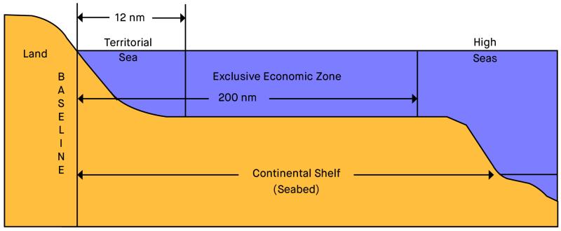
The territorial sea extends up to 12 nautical miles from a State’s baselines (which are generally drawn along the low-water line of the coast). States have control of the air-space above the territorial sea and the water column, seabed and subsoil below.

International Court of Justice (ICJ)

The main court of the United Nations, also popularly known as the ‘World Court’. Only States (i.e. countries) can be a party to proceedings before this court. The United Nations Convention on the Law of the Sea gives the International Court of Justice jurisdiction to hear maritime boundary disputes between countries. The International Court of Justice is located at The Hague in the Netherlands.

International Tribunal for the Law of the Sea (ITLOS)

A tribunal (a body which in some respects is similar to a court) which was established to resolve disputes relating to the United Nations Convention on the Law of the Sea. This includes maritime boundary disputes. The International Tribunal for the Law of the Sea is located in Hamburg, Germany.

Ratify (a treaty)

A treaty is not legally enforceable or binding on a State until that State has ‘ratified’ it. Ratification is the final stage in giving formal consent to a treaty. After a State has signed a treaty, it will generally give formal consent by either passing an act of Parliament or through a formal statement from a Government.